For a keen hiker, Sri Lanka’s luscious and diverse hill country has plenty of chances awaiting. One place in Sri Lanka that has given thousands of travellers a perfect opportunity to test their endurance is the Hikes around Nuwara Eliya. Around Nuwara Eliya, there is always a hike to match your endurance. So what is around Nuwara Eliya that makes it so famous around trekkers and h<h2ikers?
Best Places To Visit In Nuwara Eliya for Trekking and Hikes
One such place, which is most certainly considered amongst the top choices for trekkers and hikers, is the Horton Plains. It offers around five trails for hikers that start from various points. Some of these starting points are Kirigalpotha, which is the highest point in Horton Plains. Kirigalpotha is also said to be the 2nd highest mountain in Sri Lanka. The other point worth mentioning is Thotupolakanda, which is the 3rd highest mountain in Sri Lanka.
The most famous trail inside the Horton Plains National Park is the trail that leads to the World’s End. This trail suits both beginners and experts alike. Scenic cloud forests, grass plains, exciting wildlife encounters that include a few endemic bird species make this trail exciting and relaxing.
Another famous trail among the locals and visitors is the Sri Padaya or Adam’s peak. Adam’s peak is said to be a sacred place since ancient times in many religions. Locals have been worshipping at Adam’s Peak for centuries. Therefore the hike is more like a pilgrimage than a real adventure for many. At 2,243 m height above the sea level, the footprint is carved on the rock here in Adam’s peak. The footprint is believed to be very sacred in Buddhism, Hinduism, and Christianity alike.
To reach the summit, around 6 accessible trails are available starting from Ratnapura-Palabaddala, Hatton-Nallathanni, Murraywatte, Kuruwita-Erathna, Malimboda, and Mookuwatte. All these six trails have their own unique features and different difficulty levels.
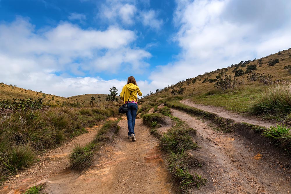
Another very famous trail among the tourists is Ella Rock. The picturesque views of the Ella Rock provide layers of cloud and mist covering the area, especially early in the mornings and late in the evenings. This is something you should not miss if you plan to take a hike to Ella Rock. I am sure the visit early in the morning or late in the afternoon would suffice enough to say that you visited Ella.
We have handpicked a few hikes around Nuwara Eliya, which are the stories of our expert trekking guides just for you.
The World’s End, Sri Lanka
World’s End Sri Lanka makes it to pretty much every adventure Sri Lanka itinerary. And there is a good reason for that. The view from the top of the 880-meter drop is superb. You can see the plains up to Udawalewe National Park, which is around 140 kilometers from Horton Plains on a clear day. Horton Plains National Park, where the World’s End is resting, is one of the most famous National Parks in Sri Lanka. It is the only National Park where you can get out and walk.

Once you reach the Horton National Park, you can set off on your hike. After walking for around 10 minutes, you will reach a fork point on the road. If you take the left path, which is the most commonly taken, you will reach World’s End quicker. The right path will first take you to Baker’s Falls and is an easier option as you will take a steeper part of the hike during your decline.
I took the left path, so I will be taking you through this route. After taking the left turn off, I walked for about 30 minutes through the grassy hills, which head right into the thick jungle. I saw a few monkeys and one huge squirrel during the walk. After this, I reached a clearing, which is the Little World’s End Sri Lanka. The view here is pretty amazing. As I was early, the sun rose over the beautiful mountains, while the clouds were whirling in the valley below it. The hill continued further up, and while I was climbing, the views got even better. Here, I stopped to capture the beauty of mother nature in its most beautiful form in my lens before I further continued on quickly down the path on the right. I was determined to be the first to arrive at the World’s End.
For the next 20 minutes of walking, I was stepping on a bit of a decline through a rocky extinct river bed. Nothing was too hard, though. And when I finally reached World’s End Nuwara Eliya, because of my early morning start, I was the first one there! This meant unlimited opportunities to capture the beauty just for myself!
After quenching my thirst for adventure and with a bountiful of pictures, it was time for my start to a somewhat anti-climactic trip back to the entrance. I took the loopback via Baker’s Falls, which can be steep at times and a little difficult as well. I started bumping into a few more people during my descend. After walking for around 30-minutes, I reached the path down to Baker’s Falls. The falls, as I heard, were absolutely amazing. From there, I walked along grassy hilltops to reach the park entrance. The entire trip took me around 2.5 hours and a memory that had me coming to Sri Lanka again and again for many years.
Hike to the Adam’s Peak
Perched in the southwestern corner of central highlands, in Sabaragamuwa province, Adam’s Peak is one of the sacred Peaks in Sri Lanka. Adam’s peak is a visually impressive mountain because of its steepness and loftiness, but that is not why it is so revered by followers of so many religions. The mountain owes its sacred status to an indentation shaped like a footprint found in a boulder at its rocky summit.
The major population of Sri Lanka, the Sinhalese, follows Buddhism. They believe that an impression which looks like a footprint was left by Lord Buddha when he visited this island country.
Muslims believe the rock formation to be a footprint but not the one left by the Lord Buddha. They believe it is Adam’s footprint, created when he took his first step on Earth after being exiled from the Garden of Eden.
The Portuguese Christians do not agree with what Buddhists and Muslims believe. They believe in the footprint but say that it was left by St. Thomas.
Whereas the Hindus living in South India believe that the footprint was made by God Shiva (one of the trinity Gods in Hinduism). They refer to the mountain as Shiva Padam in the Tamil language, which translates to ‘the Shiva’s foot.’
If you think this is it, wait! Even a 15th-century Chinese work said that the footprint was made by Pwan-Ko, the first man to have existed as per Chinese mythology.
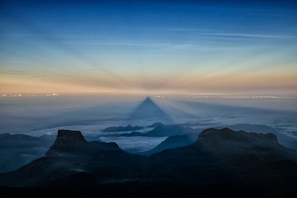
The aim of most of the pilgrims is to reach the summit just before sunrise so that they can pay homage to the footprint and witness some incredible optical illusions associated with the legendary footprint.
Depending on fitness level, the climb to the summit will probably take you anywhere between 3 and 7 hours. The distance from the starting point to the summit is around 7 km. The elevation gain is around 1,000 vertical meters, starting from 1,252 meters at the trailhead and ascending to 2,243 meters at the summit.
Plan to see the sunrise? You should start your journey from Nuwara Eliya to Nallathaniya at around 10 or 11 p.m. Your journey to the summit will have to start around midnight or 1 a.m.
We decided to set out from Nallathaniya (Dalhousie) and start our journey to the summit and descend back the mountain before nightfall.
After leaving Nallathaniya, the hike began very slowly, passing by several kiosks, shrines, massage parlours, tea houses, temples, and numerous danasalas or refuge centers offering shelter and water to pilgrims. The first thing we found near the start of the hike was a beautiful arched stone gateway called the ‘Makhura gateway,’ which marks the beginning of the proper ascent.
The gateway bears several carved figures and, at its pinnacle, a finely carved Kala motif. Kala is a jawless, ferocious monster from Hindu mythology, which symbolizes time.
After walking through this archway, the trail went alongside a lush green valley on the right and a tea plantation on the left hand, which eventually brought us to a viewpoint with several beautiful waterfalls.
We were lucky to spot a cluster of free-hanging beehives that were suspended from a tree branch. These semi-circular formations are the homes of the wild bees.
The trail continued from here, and about 2 km into the hike, we reached the foot of a staircase that leads to a plateau with a Japanese Peace Pagoda. The Pagoda was built in 1976 by one of the famous Japanese Buddhist monk, Ven Nichi Fuji. The maintenance of this Pagoda is taken care of by a group of Japanese monks.
Though there are numerous other Japanese peace pagodas in Sri Lanka, the only other one we visited was near Galle in the south. If you attempt to climb Adam’s peak at night, you can get a good look at this on your descent in the daylight.
Beyond the peace pagoda, the trail somewhat intensified, although the steps were still not particularly steep at this point. Further down the hike, you will be entering the peak wilderness sanctuary. However, you probably will not experience the sense of wildness if you climb during the pilgrimage season.
The peak wilderness sanctuary is the third-largest (by area) of the 50 wildlife sanctuaries in Sri Lanka, covering an area of 224 sq. km and mostly consisting of a misty rain forest.
This beautiful forest features some giant trees with mosses hanging from the branches and Rhododendrons displaying beautiful red blossoms. You might also see rare orchids that grow from the moist and loamy soils during your hike if you are lucky.
While we further walked to reach the summit, we came across a very interesting information sign. The sign is beside the trail, telling us about a few of the inhabitants of this amazing sanctuary.
Another interesting thing about this information sign was an interesting quote by Theodore Roosevelt. This quote was originally a reference to preserving the wilderness of the Grand Canyon in Arizona but is said to be equally applicable to all-natural treasures on this planet.
“Leave it as it is. The ages have been at work on it, and man can only mar it.”
I personally completely agree with what Mr. Roosevelt said.
The information sign gave info about this sanctuary, supporting the beautiful Ceylon magpie (Urocissa Ornata) and the purple-faced langur (Trachypithecus Vetulus). Both these species are endemic to Sri Lanka. The sign also displays various birds, lizards, butterflies, wildflowers, and several species of frogs.
In fact, in 2009, one of the rarest species of toad, Adenomus Kandianus, was rediscovered here in this very sanctuary, after it was believed to be extinct for about 133 years. Isn’t this amazing!
After gaining significant altitude by ascending the concrete steps, we ultimately stopped for a moment for the thing that I love the most, capturing our surrounding’s views. While I was still absorbing nature at its very best, suddenly, I thought of the Japanese Peace Pagoda. My eyes hurriedly started to look for it. Then, I noticed that the peace pagoda had become pretty small and now looked rather insignificant from where I was standing. We most certainly were making quite a progress.
As the trail continued to ascend, after taking a few rest stops, we reached a bridge that crossed a small stream, the Seetha Gangula. Here you can refresh yourself if the weather is warm. However, I am quite sure that water will most probably be icy cold.
Look out for the beautiful slipper flowers of Calceolaria Tripartita or the lady’s purse while you walk along here. These beautiful flowers are shaped like a little pouch and have an incredibly vibrant yellow color. After we passed the bridge, the climb started to intensify. You will now face a stretch, which is almost a non-stop climb up the concrete steps and a few sections made of rough stones.
As you ascend higher and higher, you will reach a certain vantage point called ‘Indikatapuna.’ Here, the trail suddenly begins to ascend even steeper.
This steeper part of the trail is called ‘Mahagiridamba’ or ‘the great rock climb.’ This trail continues for about 750 meters to the summit. From this point, it is all about the joint effort between your arms and your legs.
About 45 meters before the summit, we came across an interesting cave called ‘Bhagava cave.’ The cave is used as a place of refuge during bad weather. It is also a place used by ascetic monks who would live here for 9 months of the year, living only on fruits.
When you enter the cave, you will come across two very interesting inscriptions, one written in Arabic, praising Mohammed. The other one was written in the 12th century by King Nissanka Malla during his visit to Adam’s Peak.
After visiting the cave, we headed toward our ultimate goal, reaching the summit. And finally, walking for another 150 feet, we reached the summit. We all were electrified to have reached the summit. What we loved and still do was the ambiance. I am still getting goosebumps while just writing about it.
The descent was much easier than the climb and fairly quicker as well for us. We half-walked, half-ran down the 5,500 steps to reach the village before nightfall.
Hike to Ella Rock
A picture of Ella Rock is undoubtedly one of the prettiest desktop backgrounds I have ever had on my computer! No joke – the view from the top of the Ella Rock is absolutely stunning!

Around 55 km from Nuwara Eliya is one of the most picturesque hamlets of Sri Lanka, Ella. One of Ella’s main highlights is the Ella Rock, which affords one of the most breath-taking views of the terrain after a hike up the Ella Rock. Ella Rock is a famous cliff, which is situated high above Ella’s village. To reach Ella Rock, you will have to trek for around 2 to 2.5 hours.
The trek to Ella Rock is pretty simple and straightforward. We started our walk from the Ella town, which took us to a road that leads up to Ella railway station. When you enter the station, you will have to head left and walk to the platform’s end and continue your walk down the railway track!
We walked for approximately 40 minutes (including crossing over a black bridge) until we arrived at Kithalella railway station. We continued walking along the tracks past the station. Even though there are several different exits along the tracks, don’t follow them!!

About ten minutes after you pass through the train station, you get to a section of the track, which is surrounded on both sides by tall rocks covered in vegetation.
Immediately after this rock pass ends, there is a hairpin left turn. I believe this is the main spot where most people go wrong and seem to miss. It can be hard to spot with all of the vegetation as it is such a tight left turn. You need to take this hairpin turn.
About a minute after you take the hairpin turn, you will come across a bridge. After this bridge, you can only follow the path to the right.
The path takes you through a tea plantation farm, and the path will take you to a yellow house. At the yellow house, turn left up the hill, and at the top, take the right path (do not take the steps as they just end up in someone’s yard).
You will then come across an outdoor toilet to your left, and if you keep walking, you will pass through tall grass into the trees.
You then follow tree lines up the slanting hill with the valley to the right and the hilltop to your left.
Eventually, the path will slope up ahead, and there will be a ridge with a view. This is where we got our best views along the hike.
From here, it is a very steep, slippery, and tough walk up to the top of Ella Rock. There is only one way up, and so you cannot get lost on this part of the hike!
The way down was obviously a lot easier, and you cannot really go wrong with which path you take. On our way back, we had the excitement of a train chugging along the train tracks with people hanging out the doors and windows waving enthusiastically. At the same time, we stood as far back in the bushes as we could.
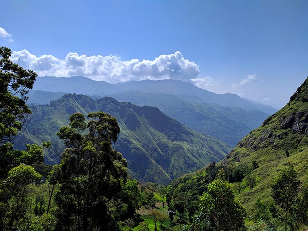
The scenery you will experience while hiking Ella Rock is beautiful, and everything was green and vibrant!
People Also Read:


